Decatur: Google vs. Yahoo vs. Bing
I came across something interesting as I was doing some research on-line and wanted to share it here.
Here are 5 "snippits" of the Decatur metro area from on-line mapping tools. Very interesting to compare & contrast them next to each other. I tried to take my "snippit" of each from the same view, so that the level of detail was as close as possible to identical.
BING:
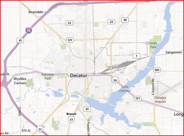
* lists WYCKLES CORNERS, instead of WYCKLES
* only 1 of 2 that does not list LARKDALE (near intersection of Mound Road and 48)
* only 1 of 2 that lists the NS-DECATUR railyard
GOOGLE:

* only one that lists FANS FIELD as a point of interest
* only one that lists NELSON PARK and ROCK SPRINGS CENTER
* FARIES PARK is shown in green, but is not labeled
* only one that does not list the DECATUR AIRPORT (not even a little plane symbol)
* only one that lists MACON COUNTY FAIRGROUNDS
* only one that does not show SANGAMON (upper right corner) or BEARSDALE (upper left corner)
* only 1 of 2 that does not list LARKDALE (near intersection of Mound Road and 48)
* only 1 of 2 that lists the COUNTRY CLUBS
MAPQUEST:

* where is NELSON PARK?
* LAKE DECATUR is not even titled; neither is the SANGAMON RIVER
RAND McNALLY:

* only one that shows GRACELAND CEMETERY AND GREENWOOD CEMETERY
* only 1 of 2 that lists both WYCKLES and WYCKLES CORNERS
* only 1 of 2 that lists the COUNTRY CLUBS
* only 1 of 2 that lists the NS-DECATUR railyard
* only 1 of 2 that lists SANGAMON RIVER
* looking at this map, the viewer would have no idea that Illinois State Highway 105 even goes through town (it's not marked and isn't in gold color like 48 and 121)
YAHOO:

* only 1 of 2 that lists both WYCKLES and WYCKLES CORNERS
* only 1 of 2 that lists SANGAMON RIVER
Neither Millikin University nor Richland Community College are shown on any of the 5 (at this level of detail at least).


.jpg)